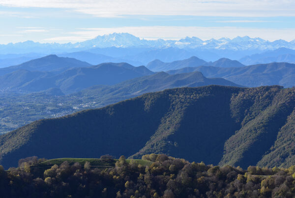
Thanks to its height of 1,325 metres, which makes it the altimetrical apex of the Municipality of Cernobbio and of the First Basin of Lake Como, and to its particular geographical location, overlooking the Lario and the lower Val Breggia, the Bisbino is a mountain with many faces, a place in which numerous elements of interest are condensed.
Mount
Bisbino
CARD 1 -Bisbino, the mountain with many faces
Thanks to its height of 1,325 metres, which makes it the altimetrical apex of the Municipality of Cernobbio and of the First Basin of Lake Como, and to its particular geographical location, overlooking the Lario and the lower Val Breggia, the Bisbino is a mountain with many faces, a place in which numerous elements of interest are condensed. The most important of these is the Sanctuary of the Madonna del Bisbino, which has been known since 1368. Situated on the summit, in a symbolic and dominant position, it consists of a building complex that has evolved over the centuries from the primitive Marian chapel. Today, above a large walled forecourt, there is a church, a porticoed vestibule, a squat stone bell tower, a hut and a small museum. In the church, which is unusual, there are two statues of the Madonna to whom the building is dedicated: one in white Musso marble, above the high altar, and one in painted wood, in the small chapel behind the altar, where numerous interesting votive offerings are also kept. The popularity of the sanctuary increased considerably after 1630, when the people of Rovenna and Swiss Sagno attributed the escaped contagion from the scourge of the Manzoni plague to the vow made to the Madonna del Bisbino. Adjacent to the sacred part of the structure is, as mentioned, the present-day Ristoro Alpino Vetta Bisbino, heir to an ancient hospice, equipped with an oven, cistern and wine cellar, which sources mention as far back as the 16th century.
Another attraction of the Bisbino is its panoramic view, which the easy access makes even more enjoyable. The summit is in fact reached by the military road, now a municipal road, built during the Great War as part of the fortification of the mountain, which made it a stronghold of the Intelvese defence line. Looking northwards and continuing clockwise, one can recognise, among others, Sasso Gordona and Colmegnone, further away Mounts Legnone and S. Primo, the Grigne, Resegone, and again near Alpe Garzegallo. To the south is the city of Como and, in the background, on a clear day, Milan, the Po Valley and the Apennines. To the west, in the distance, stands the tip of Monviso, followed, closer, by Varese and its lake, Lake Maggiore and Monte Campo dei Fiori. The distant but clearly recognisable Monte Rosa group and the closer Monte Generoso, with its rack railway and the characteristic mole of Mario Botta’s Fiore di Pietra, close the wide tour.
The pilgrims and tourists of the past enjoyed certainly wider views than those of today, thanks to the pasturelands that surrounded and characterised the summit of the mountain, in fine weather teeming with small flocks and herds. Today, most of those open spaces have given way to the reforestation carried out since the beginning of the 20th century and the natural advance of the forest.
Since the 1930s, the summit has also been home to an Air Force meteorological station, which was later also assigned the function of an observatory due to its panoramic view. No longer active today, it was first housed in a room of the sanctuary, in the eastern portion, and then in the small house behind the walls.
CARD 2 - Signs of the Great War on Mount Bisbino
Due to its favourable geographical location and moderate height (at 1,325 m it is the highest peak in the Lake Como basin), during the Great War Mount Bisbino was the southern stronghold of the northern southern stronghold of the Northern Frontier in the Intelvese Lario, which fortunately never became the theatre of battle. A series of artefacts, which time inexorably transforms but which still strongly mark the places, recall that bloody event more than a century after their construction, which took place at the height of the conflict, between 1916 and 1917.
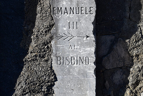
The first work carried out along the slopes of the mountain, preparatory to the formation of the preparations at altitude, is the beautiful military road named after Vittorio Emanuele III, which still today, with features of a common asphalt road, starts from Rovenna and culminates just below the summit, where a small car park. Deliberately flat and regular, and only for short distance stretches overlapping the old mule track to the mountain, it runs for about 12 kilometres, counting no less than 25 hairpin bends.
A stone pillar and two smaller stone pillars, still mark the beginning of the path, near the cemetery of Rovenna.
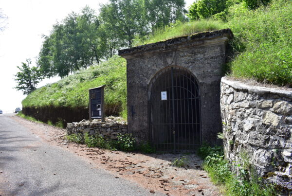
The rest of the works are on the Bisbino peak, which was precisely the southern stronghold of the intelvese defensive line, stretching along the eastern flank of the Ticino ‘wedge’. The garrison consisted of two artillery positions, each consisting of four 149 mm cannon emplacements, trenches and communication trenches and a unique tunnel observatory, accessed through a beautiful portal, with the Savoy coat of arms on the keystone of the arch, facing south along the final stretch of the military road. The fortification is roughly L-shaped, with one side of the artillery to the north and the other to the west, in order to operate in the territory between Monte Generoso and Chiasso. The direction of fire would have been directed from the tunnel observatory, built under the summit of the mountain and in the north-west organised on two levels: the low one connected to the trenches and the high one attested to two observation points, with splayed slits equipped with metal shutters of closure. The fortification see its appendices, consisting of trenches, communication trenches and shelters, push westwards almost as far as Cà Bossi and southwards to Pizzo Cavalèra. Part of the works present in the area are illustrated by some panels placed nearby them.
scheda 3 - La Linea Cadorna, rinforzo in tempo di guerra della Frontiera Nord
During the Great War, the northern border of our country was considered to be in danger: Switzerland’s ambiguous position gave rise to fears of an entry from the north by Austro-German troops, exploiting the morphology of some of the valleys, they could soon reach the nerve centres of the Po Valley.
To counter this eventuality, starting in 1916 the construction of a long and articulated line of defence was started. This articulated defensive line, stretching between the Ossola Valley and the eastern Orobie Mountains, which today is commonly known as the Cadorna Line, after the name of the general who promoted it. The works hinged on the so-called Northern Frontier Defence Line, or Northern Frontier, a defence system devised as early as the second half of the 19th century, but only implemented to a small extent, which envisaged the fortification of the northern border, considered fragile at the time, between Val d’Aosta and Stelvio. The Northern Frontier was a succession of defensive works placed in strategic sites, which as a whole formed a kind of discontinuous chain of defence against potential routes into the country.
The defensive line was divided into six sectors, of which the one called Ceresio-Lario, extended from Viggiù to Menaggio, was undoubtedly one of the most delicate: here in fact, thanks to the Ticino ‘wedge’, the Swiss border comes closest to the Lombardy plain and its capital, Milan. It was therefore affected by a particular concentration of defensive preparations, which fortunately remained inactive in the same way as the entire military establishment. In fact, despite the fears and the huge human sacrifice demanded by the conflict, the Cadorna Line was never a war front.
In January 1917, the OAFN (Occupazione Avanzata Frontiera Nord) Command was created, with the purpose of completing the fortification system and organising the defence. But the rapidly changing scenarios forced the concentration of the armed forces along the eastern border, where the fighting raged, resulting in the loss of the role of the Northern Frontier, which was still being completed. In 1919, with the conflict over, the OAFN Command was disbanded. Mount Bisbino was the southernmost stronghold of the Northern Frontier in the Lario intelvese, which, following the ridge line, drew a sort of large S starting from Mounts Galbiga and Tremezzo.